Description
It is a cutting-edge software designed to handle point cloud data precisely and easily. Whether you’re working with LiDAR data from UAV surveys or any other source, this tool offers a comprehensive set of features to streamline your workflow and maximize the value of your data.
Data Display
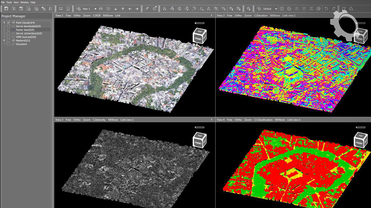
It offers a robust data display system, allowing you to visualize your point cloud data from multiple angles and perspectives. Some key features include:
- Up to 4 views that fully support 3D display.
- Point cloud display modes, including RGB, Intensity, Elevation, Classification, MIX, and File color.
- Building and displaying 3D surfaces.
- Creating 3D surfaces based on point clouds.
- Displaying surfaces in various modes such as Solid, RGB, Intensity, Elevation, Classification, Mix, and File color.
- Displaying surfaces wireframe.
- Adjusting the detail render range of surfaces for fine-tuning.
Displaying 3D Models
The software supports various 3D model formats, including GML, OBJ, 3DS, DAE, FBX, and IFC. You can display these models in different modes, such as original (with texture), uniform, advanced, and triangle mesh. Additionally, you can transform loaded models through shift, rotation, and scale adjustments.
Point Cloud Classification
It provides manual and automatic point cloud classification options, giving you full control over your data. Some classification features include:
- Definition of custom classification schemes.
- Rectangle, shape, and corridor classification.
- Classification above and below a specified line.
- Classification with a shape marker.
- Classification by Active Z.
- Classification within a specific intensity range.
Cooperation with LiMON Server
It can collaborate with LiMON Server, offering remote access to data shared over LAN/WAN. This enables project selection, displaying data based on density levels, metadata reading, and seamlessly downloading and visualizing LiDAR data.
WMS Support
The software supports Web Map Services (WMS) and allows you to define, save, and read WMS sources. You can select specific layers and work with raster data formats like JPG, JPEG, JP2, J2K, TIF, TIFF, and ECW.
Profiles
Creating profiles is a breeze with this tool. You can define polyline profiles, symmetric profiles, fixed width/length, Z scale factors, and dynamic moves. The software also includes a document creation module, enabling dimensioning based on point clouds, page size/color definition, output scale, and more. You can save the output as image files (JPG, PNG, BMP, TIF, TIFF) or export it to DXF format.
Vector Data
It supports points, lines, shapes, circles, and relative height markers. You can save and load markers in formats like KML, SHP, and TXT. Additionally, the software offers measurement capabilities, allowing you to calculate 3D distances, areas, and volumes.
Point Cloud Snapping
For precision drawing, it provides snapping to the point cloud, ensuring accurate and reliable results. You can toggle this feature on and off as needed.
Coordinate Systems
The software supports full EPSG coordinates, and offers point cloud coordinate system transformation, ensuring seamless integration with your existing data.
Camera View
The software provides extensive control over the camera view, including the camera’s origin (XYZ), direction (XYZ), focal length, and clipping box definition. You can specify clipping planes by values and adjust dynamically to achieve the desired perspective.
UAV Data Processing
It also caters to UAV-specific data processing needs, such as aligning point clouds, fitting Ground Control Points (GCP), classifying excessive coverage areas, coloring point clouds, and ensuring data quality.
Height Models
The software offers a range of height models, including Digital Terrain Models (DTM), Digital Surface Models (DSM), normalized Digital Surface Models (DSM), Canopy Height Models (CHM), and contour lines.
System Requirements
- Operating System: Windows 7, 8, 10, or 11 (64-bit)
- Processor: Intel Core i7 or equivalent
- RAM: 16GB or more
- Graphics Card: Dedicated GPU with 4GB VRAM or more
- Disk Space: 20GB of free space
- Monitor: 1920×1080 resolution or higher
- Input Devices: Mouse and keyboard
Only logged in customers who have purchased this product may leave a review.


Reviews
There are no reviews yet.