No products in the cart.

Only this weekend
Super Discount
Items on sale this week
Top picks this week. Up to 50% off the best selling products.
TatukGIS Editor is professional geographic information system (GIS) software designed for mapping, spatial data editing, and advanced geospatial analysis. It enables GIS professionals to visualize, edit, and manage a wide range of geospatial datasets with precision and flexibility.
This is full version for Windows PC. With this software included Virtual Dongle (License file) for lifetime activation. License Type: Perpetual Offline (Non-Updatable).
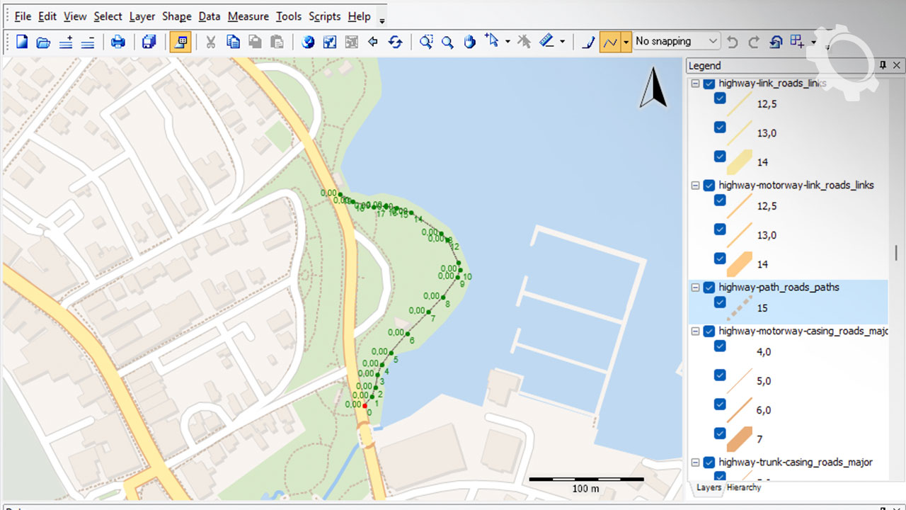
TatukGIS Editor is advanced mapping and spatial data editing software ideal for government agencies, engineering firms, and GIS consultants. It provides powerful tools for working with vector and raster datasets, creating custom maps, querying spatial information, and producing high-quality cartographic outputs.
The software supports accurate geospatial analysis, database integration, and customizable workflows for diverse GIS, surveying, and environmental applications.
Professional GIS mapping and visualization
Vector and raster data editing
Attribute table and database management
Spatial queries and analysis
Coordinate reference system support
Custom map layouts and cartography
Import/export of multiple GIS formats
Geospatial vector layers
Raster imagery and surface data
Attribute and spatial relationships
Spatial topology and connectivity
GIS queries and analysis results
Custom map compositions
Government planning departments
Engineering and surveying firms
Environmental and conservation organizations
Utility and infrastructure mapping
Urban planning and land development
GIS analysts
Cartographers
Surveying professionals
Environmental scientists
Urban planners
Flexible GIS data editing tools
Comprehensive spatial analysis capabilities
High-quality map production
Support for diverse geospatial formats
Customizable GIS workflows
Purchase TatukGIS Editor with secure digital delivery.
Ideal for professionals requiring robust GIS mapping and spatial data editing software.
Q1: What is TatukGIS Editor used for?
TatukGIS Editor is used for GIS mapping, spatial data editing, and geospatial analysis.
Q2: Is TatukGIS Editor suitable for environmental mapping?
Yes. It supports GIS workflows used in environmental and conservation applications.
Q3: Can TatukGIS Editor handle raster and vector data?
Yes. It includes tools for both raster imagery and vector layers.
Q4: Does TatukGIS Editor support spatial queries?
Yes. It allows querying spatial relationships and attributes.
Q5: Who should use TatukGIS Editor?
GIS analysts, cartographers, and urban planners.
Q6: Is TatukGIS Editor useful for infrastructure mapping?
Yes. It is widely used in utility and infrastructure projects.
Only logged in customers who have purchased this product may leave a review.


Reviews
There are no reviews yet.